


Tocvan Drone Magnetic Data Strengthens Gold-Silver Targets Across Gran Pilar; Identifies Broad Zones for Expansion Potential - Seite 2
 649
 0 Kommentare
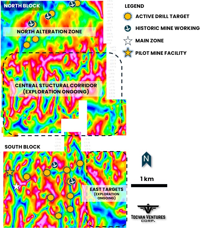
Figure 1. Drone magnetic survey map showing tilt derivative of the Reduced to Pole (RTP) and priority target areas identified to date by geological mapping and surface geochemistry.
Summary of the Data
The processed magnetic data includes Total Magnetic Intensity (TMI), TMI Reduced to the Pole (TMI-RTP), Calculated First Vertical Derivative (1VD) of the TMI-RTP, and Tilt Derivative of the TMI-RTP.
The survey provides comprehensive geophysical datasets that map magnetic field variations across the project area. Key components include:
-
Total Magnetic Intensity (TMI): Raw measurements of the Earth's magnetic field strength.
-
TMI Reduced to the Pole (TMI-RTP): Adjusted data to simulate measurements at the magnetic north pole, improving anomaly interpretation.
-
First Vertical Derivative (1VD) of TMI-RTP: Enhances detection of near-surface features and structural boundaries.
-
Tilt Derivative of TMI-RTP: Aids in identifying the depth and geometry of magnetic sources.
The Gran Pillar Project, Sonora, Mexico
100% CONTROLLED PRIORITY TARGETS FOR TRENCHING & DRILLING
-
South Block Main Zone Expansion
-
Follow-up on 2025 Drill Success
-
19.4 g/t Au over 3.1 meters within 106.6 meters of 0.6 g/t Au (February 25, 2025 News Release)
-
5.4 g/t Au over 6.1 meters within 41.2 meters of 1.0 g/t Au (May 7, 2025 News Release)
-
136 g/t Ag over 10.7 meters within 42.7 meters of 41 g/t Ag (June 25, 2025 News Release)
-
-
-
South Block (November 12, 2024 News Release)
-
Placer Corridor (900-meter strike length)
-
Soil samples up to 21.2 g/t Au and >2,000 g/t
-
-
Placer Source Area
-
Soil samples up to 2.4 g/t Au and 22 g/t Ag
-
Rock samples up to 7.3 g/t Au and 389 g/t Ag
-
-
-
North Block
-
North Alteration Zone (3.2 km by 1.5 km area)
-
Diskutieren Sie über die enthaltenen Werte


 URL kopieren
 Per E-Mail teilen
 Artikel drucken
